Norway’s $47B Coastal Highway: Building the World’s First Floating Tunnels
Norway is embarking on the largest infrastructure endeavor in its national history and arguably the most ambitious civil engineering initiative in the world today. With an estimated initial budget of $47 billion—and potential total investments reaching even higher—the new Coastal Highway Route E39 (known locally as Ferjefri E39) is set to completely overhaul transportation along the country’s western corridor.
Currently, traveling the full stretch of the western coast requires navigating a complex network of highways and seven separate fjord ferry crossings. What is today an arduous 21-hour journey will soon be cut down to less than half that time. By replacing conventional ferries with record-breaking bridges, subsea rock tunnels, and groundbreaking submerged floating tube bridges, Norway is redefining modern transport engineering.
1. The Economic Imperative Behind Route E39
Norway’s western coastline is a vital economic engine for the nation. While famous worldwide for its dramatic landscapes, steep cliffs, and deep waters, the region is also home to a third of Norway’s total population and generates roughly 60% of its exported goods.
┌─────────────────────────────────────────────────────────┐
│               WEST NORWAY ECONOMIC SNAPSHOT             │
├──────────────────────────┬──────────────────────────────┤
│ Regional Parameter       │ Value / Percentage           │
├──────────────────────────┼──────────────────────────────┤
│ Share of Population      │ ~33% of national total       │
│ Share of Export Goods    │ ~60% of national total       │
│ Current Travel Time      │ ~21 hours (Kristiansand-Trondheim) │
│ Current Ferry Crossings  │ 7 active fjord routes        │
└──────────────────────────┴──────────────────────────────┘
Moving goods—particularly wild-caught and farmed seafood, oil and gas components, and heavy industrial exports—requires constant transport along the coastal axis. Under the current setup, logistics providers face recurring delays, high fuel costs, and scheduling friction tied to ferry operations.
2. The Logistics Bottleneck: 21 Hours and 7 Ferries
The current E39 route spans approximately 1,100 kilometers (680 miles) between Kristiansand in the south and Trondheim in the north. Because the coastline is deeply carved by fjords, drivers face seven mandatory ferry legs along the trip.
The True Cost of Ferry-Reliant Travel
Time Penalties: Each ferry crossing takes roughly 45 minutes of transit time, excluding queueing, boarding, and unloading periods.
Direct Expenses: A single passenger car incurs over $200 in fuel costs for a one-way trip, alongside individual ferry fares averaging around $16 per crossing.
Commercial Delays: Freight haulers must calculate strict driving-time limits around fixed ferry schedules, leading to costly idle times during off-peak hours or night sailings.
While tourists may appreciate the scenic breaks provided by a fjord ferry, commuters, emergency medical services, and commercial transport drivers find the current network deeply inefficient.
3. The Grand Plan: Connecting Kristiansand to Trondheim
To eliminate these barriers, the Norwegian Public Roads Administration (Statens vegvesen) designed a comprehensive overhaul of the E39 corridor. The goal is to establish a continuous, ferry-free highway system running at consistent highway speeds.
                      E39 HIGHWAY TRANSFORMATION

      CURRENT STATE                                  FUTURE GOAL
  ┌──────────────────┐                           ┌──────────────────┐
  │ 21-Hour Transit  │                           │ <11-Hour Transit │
  │ 7 Fjord Ferries  │ ────────────────────────> │ 0 Fjord Ferries  │
  │ Average 30 mph   │    $47B+ Infrastructure   │ Continuous Flow  │
  └──────────────────┘                           └──────────────────┘
By substituting water barriers with fixed crossings, the project will boost the average travel speed across the corridor from a sluggish 30 mph to standard highway speeds, unifying regional labor markets across Western Norway.
4. Engineering Marvel: The Submerged Floating Tube Bridge (SFTB)
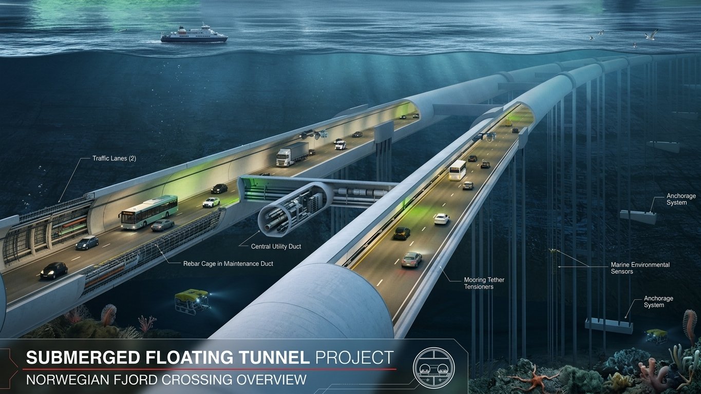
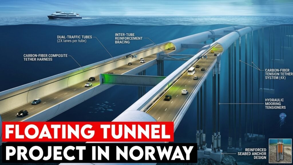
The most innovative aspect of the E39 project is the proposed use of Submerged Floating Tube Bridges (SFTBs)—often referred to simply as floating tunnels.
                     ┌───────────────────────┐
                     │ Submerged Tube Bridge │
                     └──────────┬────────────┘
                                │
        ┌───────────────────────┴───────────────────────┐
        ▼                                               ▼
┌──────────────────────────────┐        ┌──────────────────────────────┐
│  Surface Pontoon System      │        │  Seabed Tether System        │
│  Tubes suspended from ships  │        │  High-tension cables anchored│
│  or floating surface platforms│        │  directly into bedrock       │
└──────────────────────────────┘        └──────────────────────────────┘
An SFTB consists of twin concrete structures submerged approximately 60 to 150 feet (18 to 45 meters) below the water’s surface. This placement solves multiple engineering challenges at once:
Weather Isolation: Positioned safely beneath wave action, the tunnel remains unaffected by severe coastal storms, high winds, or icy surface conditions.
Navigational Clearance: Large commercial vessels, cruise ships, and naval submarines can pass directly over or around the structure without collision risks.
Unlimited Depths: Because the structure relies on buoyancy balance rather than ground pillars, an SFTB can theoretically span deep bodies of water of unlimited depth.
5. Why Traditional Bridges Fail in Norway’s Fjords
Engineers are often asked why Norway cannot simply erect standard suspension bridges across its waterways. The answer comes down to geology and scale.
| Challenge Factor | Traditional Suspension Bridge | Submerged Floating Tunnel (SFTB) |
| Fjord Depths (>100m) | Requires massive, impractical support towers | Unaffected by water depth due to neutral buoyancy |
| Fjord Widths (>2-3km) | Demands record-setting arch spans | Scalable across wide distances without land anchorage |
| Severe Weather | High risk of closure due to gale-force winds | Completely protected beneath surface wave action |
| Environmental Impact | Visually dominant; large shoreline footprints | Virtually invisible, preserving local coastal scenery |
When a fjord extends deeper than 100 meters or wider than 3 kilometers, traditional bridge towers become engineering impossibilities. Anchoring rock-tunnel portals deep underground also requires excessive land usage on fragile shorelines, making SFTBs the most viable alternative.
6. The Rogfast Tunnel: World’s Deepest and Longest Subsea Road
While floating tunnels handle the widest crossings, extreme subsea rock tunnels handle others. The flagship section currently under construction is the Rogfast Tunnel (Boknafjord Tunnel).
Key Specs of the Rogfast Tunnel
-
Maximum Depth: 390 meters (1,280 feet) below sea level.
-
Total Length: 27 kilometers (16.7 miles) of dual-tube highway.
-
Completion Target: Updated timeline targets full operation around 2029–2033.
-
Toll Structure: Designed to feature a 20-year toll collection window post-opening (approx. $16 per light vehicle).
Once complete, the Rogfast structure will claim the title of both the deepest and longest undersea road tunnel on the planet, featuring a subterranean junction deep beneath the islands of Kvitsøy.
7. Budget Realities: Managing a $47 Billion Mega-Project
Constructing infrastructure of this magnitude comes with substantial financial challenges. While initial estimates placed the master project budget around $47 billion, updated engineering evaluations indicate the total cost could require an additional 340 billion Norwegian kroner (approx. $38 billion extra).
                         FINANCING MODEL

    ┌─────────────────┐   ┌─────────────────┐   ┌─────────────────┐
    │ State Transport │ + │ Local Toll      │ + │ Intelligent     │
    │ Allocations     │   │ Revenue (20-yr) │   │ Grid Efficiency │
    └────────┬────────┘   └────────┬────────┘   └────────┬────────┘
             │                     │                     │
             └─────────────────────┼─────────────────────┘
                                   │
                                   ▼
                       ┌───────────────────────┐
                       │ Fully Funded Megalink │
                       └───────────────────────┘
To manage these costs without overburdening public budgets, the Norwegian government utilizes a hybrid financing strategy. State transportation grants are paired with targeted tolling systems on completed sections, ensuring that infrastructure costs are amortized over decades of commercial use.
8. Preserving the Landscape: Eco-Friendly Infrastructure Design
Norway’s natural fjords are protected UNESCO World Heritage sites and critical ecosystems. Building sprawling above-ground highways or massive bridge anchors would disrupt habitats and scar pristine environments.
By hiding key traffic corridors underground and underwater:
-
Visual Footprints Are Minimized: Shorelines remain pristine, supporting local eco-tourism.
-
Emissions Are Reduced: Cutting travel times by 10+ hours significantly lowers overall vehicle emissions along the corridor.
-
Smart Grids Keep Operations Green: The road network incorporates renewable energy sources, such as solar arrays and geothermal systems, to power lighting, ventilation, and automated road-deicing technologies.
9. Reversing Rural Depopulation in Scandinavia
Beyond logistics, Route E39 carries a crucial social mandate: reversing severe rural depopulation across Western Norway. Over the last century, some remote fjord communities have lost over 50% of their populations due to geographic isolation.
When access to major urban centers requires hours of travel and ferry schedules, young professionals, healthcare workers, and businesses naturally relocate to larger cities. By linking isolated districts directly to regional urban hubs, the new highway ensures fast access to:
-
Regional hospitals and emergency medical facilities
-
Higher education campuses and vocational centers
-
Diverse job markets within reasonable commuting distances
10. A Global Model for Future Engineering
The technologies pioneered along the E39 corridor are establishing new benchmarks for global civil engineering. From marine research collaboration with the Norwegian University of Science and Technology (NTNU) to breakthroughs in underwater concrete durability, the project provides a blueprint for coastal nations worldwide.
As sea levels rise and coastal populations grow, the ability to build resilient, submerged, and floating transport corridors will prove invaluable for transportation departments across the globe.
Frequently Asked Questions
What is a submerged floating tube bridge (SFTB)?
A submerged floating tube bridge is a sealed concrete or steel structure suspended underwater (typically 60 to 150 feet deep) using surface pontoons or seabed tethers. It allows vehicles to drive underwater without resting on the sea floor.
How do floating tunnels handle severe weather and waves?
Because SFTBs are submerged tens of meters below the surface, they sit under the impact zone of surface waves and storm surges. Their buoyancy balance and tethering systems prevent excessive movement during rough sea conditions.
Is the Rogfast Tunnel open yet?
No. Construction on the Rogfast Tunnel began in 2018. Following technical revisions and budget adjustments, completion is currently targeted for the late 2020s to early 2030s.
How will the E39 project affect travel times?
The project will reduce total drive times between Kristiansand and Trondheim from 21 hours down to approximately 11 hours, while eliminating all seven current ferry crossings.
Are floating tunnels safe from ship collisions and submarines?
Yes. SFTBs are positioned deep enough to allow surface vessels and submarines to navigate over them safely. Surface pontoons are also spaced and illuminated to alert marine traffic to the tunnel corridor.
How much will it cost drivers to use the new route?
While general roads remain free, major megastructures like the Rogfast Tunnel will use electronic tolling systems (charging roughly $16 per passage for light vehicles) for approximately 20 years to offset construction costs.
Recommended Internal Links & External References
Internal Link Suggestions
-
Undersea Tunnel Innovations: How deep-rock tunneling technology has evolved over the past century.
-
The Economics of Mega-Projects: Balancing cost overruns and long-term GDP growth in public infrastructure.
-
Sustainable Transport Grids: Integrating solar heating and smart sensors into modern highway design.
-
Scandinavia’s Demographic Shifts: How connectivity initiatives are restoring rural economies.
External Authoritative References
-
Norwegian Public Roads Administration (Statens vegvesen) – E39 Project: Official updates and engineering specifications for Route E39.
-
Norwegian University of Science and Technology (NTNU) – Department of Structural Engineering: Research insights on submerged structural mechanics and marine engineering.
-
International Tunnelling and Underground Space Association (ITA-AITES): Global standards and technical papers on subsea and floating tunnel design.